

Counting Sheep and People: A Census-ational Journey
15th February 2024

What is the Census?
Every ten years, the Office for National Statistics (ONS) undertakes a nationwide survey in England and Wales, capturing data on households and demographics. The National Records of Scotland and the Northern Ireland Statistics and Research Agencies conduct their own censuses at similar intervals in their respective countries. The data collected typically includes age group, gender, house type, ownership, and occupation. At GMAP, we are always excited to delve into exploring and operationalizing the latest census data, such as in our previous blog about the census (see here), as it reveals the UK’s growth and diversity.
Censuses, however, are far from a modern invention! The oldest surviving census data is from 2 CE in China’s Han Dynasty, revealing a population of 57.7 million people living in 12.4 million households. Babylonian civilizations in 4000 BC began using censuses for food and resource allocation among their growing populations. Nowadays, the census is used by the government and local authorities to inform decisions and resource allocation regarding social programs, infrastructure development, education planning, and housing policies, among other uses. Every day, you and I are likely using services that have been partly influenced by the census without even realizing it!
For the same reasons authorities use census data to increase the value of providing and improving public services, commercial companies can benefit hugely from understanding a country’s geodemographics to maximize customer selection and retention.
The Census in Location Planning
Most famously, the census contains data on population geodemographics – ages, genders, and ethnicities of people across the country. For instance, a low-cost gym centre will need to situate its facilities in locations with large, dense populations, preferably of a younger demographic, to maximize memberships. Conversely, a high-end specialist well-being facility company will likely situate its facilities in high-population areas with an older age demographic.
The census also provides data on income and employment, which is important for authorities in planning suitable public services and for private companies in siting outlets in locations that fit their target demographic. For instance, lower-budget supermarkets such as Aldi and Lidl are more likely to situate stores in areas with higher proportions of lower-income households, as opposed to Waitrose and Booths, which may target high-income neighbourhoods or towns.
Other variables contained within the census include cultural and language diversity, which can also be strong indicators of the types of companies more likely to thrive in certain areas. As town and country-level demographics can change significantly over decadal periods, keeping on top of the latest census data is a surefire way to ensure your business establishes and thrives in the right locations.
The Census at GMAP
Being a people-focused organization, the census is at the core of much of our work, and for this reason, it is built into our specialist location intelligence software, MVPLUS, as a standard feature. Currently, most 2011 Census data is available in MVPLUS, and the 2021 Census data for England and Wales is also accessible for comparison. However, the Scottish and Northern Irish Censuses are not yet available. They are expected to be accessible in Spring 2024 when our development team will integrate them into your MVPLUS Systems.
The census serves as the cornerstone of much of our work, as a people-focused organization committed to leveraging comprehensive location intelligence data for informed decision-making. In line with this commitment, we have seamlessly integrated it into our specialized location intelligence software, MVPLUS, as a standard feature. Currently, we have incorporated the 2011 Census data, providing valuable insights for our analyses. Additionally, we have included the 2021 Census data for England and Wales to facilitate meaningful comparisons and enrich our understanding of demographic trends. The Scottish and Northern Irish Censuses are not yet available, but they are expected to be accessible in Spring 2024 when our development team will integrate them, further enhancing the depth and breadth of our location intelligence tools. Combined with our geodemographic products such as CAMEO, an even more comprehensive consumer geodemographic classification can be generated for optimal retail or automotive location planning.
Below are some examples of how census in MVPLUS can immediately help inform location decisions:
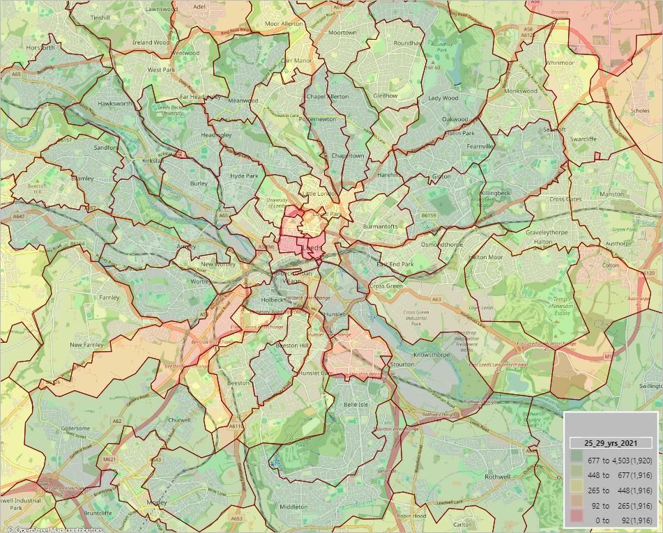
Image 1, created in MVPLUS, illustrates the variation in populations of 25–29-year-olds in post sectors surrounding Leeds. A gym chain could leverage this information, combined with other indicators, to identify the most suitable post sectors in Leeds for siting a new gym with optimal client numbers.
Conversely, a high-end luxury brand might be interested in discovering neighbourhoods with the highest incomes, typically associated with high-level professional jobs. Identifying these areas is crucial for the brand, as customers residing in such neighbourhoods are more likely to engage with and utilize their products and services.
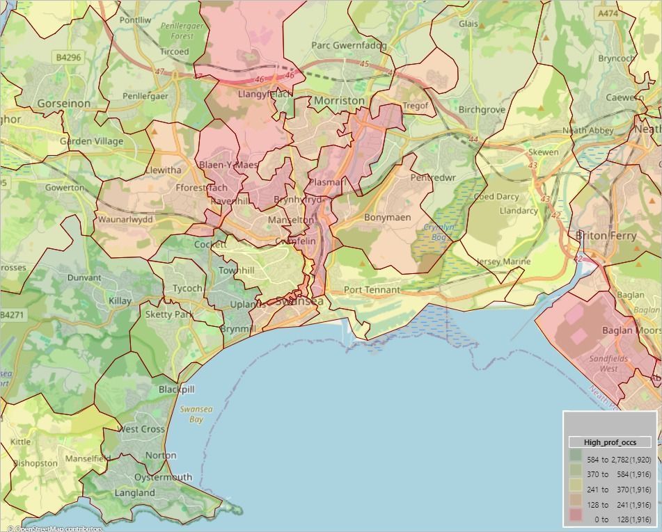
A luxury brand, when presented with Figure 2 mapping their likely customers, would probably choose to position their next store or service in the western part of the city centre.
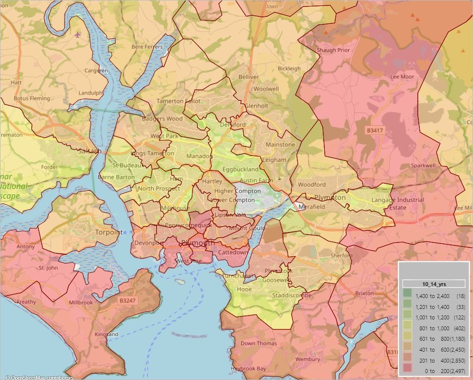
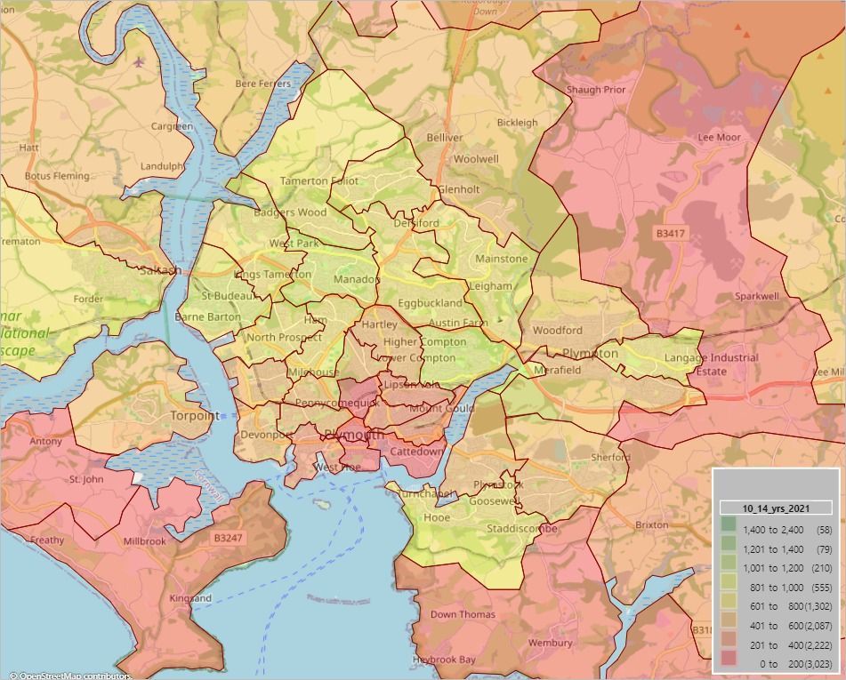
Images 3 and 4 illustrate the importance of using the most recent census data for analysis – demographics change! For example, a trampoline park venue chain could analyse how the distribution of their primary user base has changed since 2011 in the suburbs of Plymouth. This analysis would help them identify geodemographic shifts and determine if the optimal location for their next venue may have changed over time.